CO
Rocky Mountain National Park
Colorado's tenth national park, where Trail Ridge Road climbs to 12,183 feet and elk bugle in the meadows below Longs Peak.
Established
We haven’t been to Rocky Mountain yet. This page is the homework we’re doing before we drive in: how to handle the thin air, what’s worth the stop with small legs, and the permit and weather rules that catch families off guard. The structured sections below are the plan; we’ll come back and rewrite the top once we’ve actually stood on the tundra.
Altitude shapes this trip more than mileage does. Bear Lake sits at 9,475 feet, Trail Ridge Road tops 12,183, and the Alpine Visitor Center is the highest in the system at 11,796, high enough that day-one visitors get winded fast and wake up with headaches. The plan is a night at Estes Park, around 7,500 feet, to let everyone adjust before climbing higher. The flat loops carry the days with kids: Sprague Lake and Lily Lake are both about 0.8 miles and stroller-friendly, and Bear Lake to Emerald is the medium hike worth the early start. Longs Peak, the only fourteener here at 14,259 feet, is a class 3 scramble that has killed more than sixty people since 1884. We expect to look at it from a Trail Ridge pullout with Big and Little, not climb it.
The park sits across the homelands of the Nuuchiu (Ute), who used the country west of the Continental Divide, and the Hinono’ei (Arapaho), who used the country to the east; the Tsistsistas (Cheyenne) moved through the range too. The traverse later paved as Trail Ridge Road follows a corridor Indigenous peoples crossed for thousands of years. In 1914, a year before the park was established, Arapaho elders Gun Griswold and Sherman Sage rode a two-week pack trip with student Oliver Toll and interpreter Tom Crispin and recorded Arapaho names for dozens of features, a record the NPS keeps online.
Two logistics decide the rest. The first is the timed-entry permit, which the park has run since 2020, roughly late May through mid-October, with a separate Bear Lake Road Corridor permit for the popular lake hikes; we’ll confirm the current season’s dates on the NPS page before we lock anything. The second is timing the visit to early fall, mid-September into early October, when the elk rut fills Moraine Park with bugling, the aspens turn, the crowds thin, and Trail Ridge Road is usually still open before the first hard snow shuts it for the winter.
I
Basic info
- Established
- 1915
- Area
- 265,807 acres
- Visitors (2023)
- 4,108,816
- Elevation
- 7,500–14,259 ft
- Designation
- National Park (1915)
- Designation
- UNESCO Biosphere Reserve (1976)
II
Logistics
Before you go
- Getting there
- From Denver, take I-25 to US 36 through Boulder to Estes Park, about 66 miles and 1.5 to 2 hours. Denver International Airport is the closest major airport, and Grand Lake is the west-side gateway. NPS
- How many days
- NPS says to put aside at least half a day for Trail Ridge Road, which crosses 48 miles from Estes Park to Grand Lake with 11 miles above treeline. The half-hour Tundra World Nature Trail at Rock Cut is one stop along the way. NPS
- Entrance fee
- Entry costs $30 per private vehicle for 1 day or $35 for 7 days (2026). An America the Beautiful pass covers entry, and from late May to mid-October you may also need a timed-entry reservation, depending on where and when you enter. NPS
- Pets
- Only along roads, in parking areas, and in campgrounds and picnic areas, on a leash 6 feet or shorter (2026). All trails, tundra, meadows, and visitor centers are closed to pets. NPS
Seasons
Spring
- Lower elevations open while plows work the high road. Trail Ridge Road usually stays closed into late May. Wildflowers begin late in the month.
- 30s to 60s °F at the gateways, colder up high. Mud and lingering snow on the trails.
- Bear Lake Road and the montane meadows are the reachable plan. Sprague Lake and Lily Lake are good early-season walks for the family while the tundra is still under snow.
Summer
- Everything open, crowds peak in July, and the timed-entry permit system runs. Afternoon thunderstorms build most days.
- 70s to 80s °F at Estes Park, 40s to 60s °F on the tundra. Lightning above treeline by early afternoon.
- The full park is reachable. Cross Trail Ridge Road early, start the Bear Lake hikes before the lots fill near 7 a.m., and be below treeline before noon storms.
Fall
- The elk rut runs mid-September to mid-October and the aspens turn around the third week of September. Trail Ridge Road closes with the first hard snow, usually mid-October.
- 40s to 70s °F, cold nights. Clear bugling mornings in the meadows.
- The season the family would plan a trip around. Moraine Park, Horseshoe Park, and Upper Beaver Meadows hold the elk; keep 75 feet back per NPS.
Winter
- Bear Lake Road stays open to Bear Lake; Trail Ridge Road is closed past Many Parks Curve. Snowshoe and ski terrain opens in Glacier Basin, Moraine Park, and Wild Basin.
- Teens to 40s °F, wind-driven snow up high. Short daylight.
- The quiet season. Sunrise at Bear Lake, snowshoe loops in the lower meadows, and no timed-entry permit required.
Rocky Mountain National Park with kids
Rocky Mountain is an altitude park before it is a hiking park. Bear Lake sits at 9,475 feet and Trail Ridge Road tops 12,183 feet, high enough that day-one visitors get winded and headachey, so the family plans a night at Estes Park (about 7,500 feet) to adjust before climbing higher. The headline lake hikes leave from the Bear Lake Road Corridor, which is inside the timed-entry zone and whose lots fill by about 7 a.m. in summer. The flat loops and the elk meadows carry the trip with small legs; the fourteener and the long gorge hikes are for looking at, not for climbing with kids.
- Junior Ranger and Junior Ranger Night Explorer booklets are free at every visitor center.
- Strollers work only on the Sprague Lake and Lily Lake loops; everything else is dirt, rock, or steps.
- Sprague Lake (0.8 mi, flat) and Lily Lake (0.8 mi, flat, outside the permit zone) are the easiest wins. Bear Lake to Emerald (about 3.5 mi) is the best medium family hike.
- Skip Longs Peak with kids: the Keyhole Route is a class 3 scramble with real exposure, not a walk-up. See it from the Trail Ridge pullouts or from Estes Park instead.
- Altitude is the real risk. Hydrate, climb gradually, and watch kids for headache and nausea above 9,000 feet. Get below treeline before the noon storms in July and August.
Accessibility
Two flat lake loops are fully accessible, and the highest country in the park is reachable by car on Trail Ridge Road, so a family can stand on alpine tundra without a hike. The Alpine Visitor Center sits at 11,796 feet right off the road. Most named trails beyond the accessible loops are dirt and rock with grade.
- Sprague Lake Loop: a flat 0.8-mile accessible, stroller-friendly loop on Bear Lake Road with the Continental Divide reflected off the water; a wheelchair-accessible backcountry campsite is at the lake.
- Lily Lake Loop: a flat 0.8-mile loop off Highway 7 on a mostly accessible surface, outside the timed-entry zone, with Longs Peak across the water.
- Alpine Visitor Center: reachable by car at 11,796 feet when Trail Ridge Road is open; the building and overlook are near-level, though the Alpine Ridge Trail above it is steep steps.
- Many Parks Curve and the other Trail Ridge pullouts are paved car-door overlooks. Bear Lake, Emerald Lake, and the gorge trails are unimproved and not accessible.
Things you can't miss
Natural places
Bear Lake↗
A subalpine lake at 9,475 feet at the end of the 9.2-mile Bear Lake Road, ringed by conifers under the Continental Divide. A flat 0.6-mile nature-trail loop circles the water, and the same trailhead launches the Nymph, Dream, and Emerald lake chain, Lake Haiyaha, and Flattop Mountain. The basin sits in high country the Nuuchiu (Ute) and Hinono'ei (Arapaho) both used seasonally. The lot fills by about 7 a.m. in summer and is inside the Bear Lake Road Corridor timed-entry zone; the Park-and-Ride shuttle is the backup.
Longs Peak↗
At 14,259 feet, the only fourteener in the park and the high point of the skyline from the east. The standard Keyhole Route is a class 3 scramble with serious exposure, not a walk-up; the park has recorded more than 60 deaths on the mountain since 1884. This is a viewing feature for a family, not a hike with kids. The best looks come from the Longs Peak and Mount Meeker pullouts on Trail Ridge Road or straight on from Estes Park.
Trail Ridge Road↗
U.S. 34 runs 48 miles between Estes Park and Grand Lake and tops out at 12,183 feet, the highest continuously paved through-road in the country, with 11 miles above treeline. It follows a high traverse the Nuuchiu and Hinono'ei used to cross the Divide for thousands of years. The road is open from about Memorial Day weekend to mid-October; 2025 ran May 30 to November 14. Pull-offs include Many Parks Curve, Rainbow Curve, and Forest Canyon Overlook.
Sky Pond and Glacier Gorge↗
Sky Pond sits below the Cathedral Spires at the head of Glacier Gorge, reached past The Loch and a hands-on scramble up beside Timberline Falls, roughly 9 miles round trip with about 1,780 feet of gain from the Glacier Gorge Trailhead. This is a long day, not a kid hike, in the same high travel country the Nuuchiu and Hinono'ei used. Most families turn around at The Loch (about 5.6 miles round trip), which is plenty of country on its own.
Nearby attractions
Estes Park↗
The east-side gateway town, at the Beaver Meadows and Fall River entrances. It sits at about 7,500 feet, which makes it the place to spend night one and let the family adjust to altitude before climbing higher. The valley was Hinono'ei (Arapaho) summer country, and the 1914 Toll pack trip recorded Arapaho names for features in view of town. The Big Thompson River runs through downtown; the riverwalk is a flat, free leg-stretch. Verizon coverage works here, where inside the park it mostly does not.
Holzwarth Historic Site↗
A preserved dude ranch that ran from 1917 to the early 1970s, on the Colorado River headwaters in the Kawuneeche Valley near the Grand Lake entrance. The valley sits on the west side of the Divide in Nuuchiu (Ute) country; rangers staff the cabins in summer, and the walk in from the trailhead is flat. It pairs with a Trail Ridge Road crossing to the quieter west side. Much of the surrounding country burned in the 2020 East Troublesome Fire, so check NPS for current access.
Places to stay
Moraine Park Campground↗
The largest campground in the park and the only one open year-round, in Moraine Park at about 8,160 feet and reservable on recreation.gov. It sits inside the elk-rut meadows, so bugling carries into the loops on September and October nights. It is the closest developed campground to the Bear Lake Road Corridor and the Beaver Meadows Visitor Center. Moraine Park is a broad montane meadow both the Nuuchiu and Hinono'ei used as seasonal hunting ground.
Stanley Hotel↗
The full-service hotel option in Estes Park for families who would rather not camp at altitude on night one. F.O. Stanley, co-inventor of the Stanley Steamer automobile, opened it in 1909 on a hill above town with a straight-on view of Longs Peak and the Front Range. A 1974 stay inspired Stephen King's The Shining, which the hotel leans into; day tours run year-round and rooms book direct.
Viewpoints and camping
Alpine Visitor Center↗
At 11,796 feet, the highest visitor center in the National Park System, on Trail Ridge Road at the top of Old Fall River Road and open only when the road is. The short, steep Alpine Ridge Trail climbs above it for a tundra view; the elevation alone winds adults and kids on day one. The tundra here is part of the high traverse the Nuuchiu and Hinono'ei used to cross the Divide.
Sprague Lake↗
A flat 0.8-mile loop around a lake on Bear Lake Road, fully accessible and stroller-friendly, with the Continental Divide reflected off the water in calm morning light. It is the one viewpoint in the park a stroller can reach, with a picnic area and a wheelchair-accessible backcountry campsite at the lake. Calm light and a flat loop make it the first walk to do while the family is still adjusting to the altitude.
Trails worth the time
Bear Lake to Emerald Lake↗
Three lakes on one climb under Hallett Peak: Nymph, Dream, and Emerald, all from the Bear Lake Trailhead at 9,475 feet. The Dream Lake leg alone is 2.2 miles round trip with 425 feet of gain per NPS; Emerald is roughly 3.5 miles round trip with about 705 feet of gain. The best medium family hike in the park. It is inside the Bear Lake Road Corridor timed-entry zone, so start early for parking.
Lily Lake Loop↗
A flat loop around a lake off Highway 7 south of Estes Park, outside the timed-entry zone, so it needs no permit to reach. The surface is mostly accessible, and Longs Peak and Mount Meeker rise straight ahead across the water. It needs no timed-entry permit and no shuttle, which makes it the rare Rocky Mountain trailhead a family can reach on a whim.
Wild Basin to Ouzel Falls↗
Climbs the south-end Wild Basin drainage past Copeland Falls and Calypso Cascades to Ouzel Falls, away from the Bear Lake crowds. The trail runs creek-side most of the way, which keeps kids moving, and the Wild Basin Trailhead near Allenspark sits outside the main timed-entry corridor. About 5.4 miles round trip with roughly 950 feet of gain.
Our pick for things to do nearby
Elk rut viewing↗
Bull elk bugling peaks from mid-September to mid-October in Moraine Park, Horseshoe Park, and Upper Beaver Meadows, the meadow basins the Nuuchiu and Hinono'ei used as seasonal hunting ground. Rangers run rut-season meadow closures and dusk traffic control; NPS asks visitors to stay 75 feet from elk. The one wildlife event a family can plan a fall trip around, with no permit and no climbing required.
Common questions
- When should we go with kids?
- Mid-September to early October if you can. The elk rut is on, the aspens turn around the third week of September, the crowds thin after Labor Day, and Trail Ridge Road is usually still open. July and August have the warmest weather and every trail open, but also the heaviest crowds, daily afternoon lightning above treeline, and full lots by 7 a.m.
- Do we need a timed-entry permit?
- Usually yes in summer and early fall. The park has run a timed-entry permit system since 2020, active roughly late May through mid-October, with one permit for park access (9 a.m. to 2 p.m.) and a separate Bear Lake Road Corridor permit (5 a.m. to 6 p.m.) that covers the popular lake hikes. Permits book on recreation.gov. The program is renewed year to year, so confirm the current season's dates on the NPS page before you lock plans.
- How do we handle the altitude?
- Sleep low first. Estes Park sits around 7,500 feet, Bear Lake is 9,475, and Trail Ridge tops 12,183, high enough that day-one visitors get headaches and nausea. Spend a night at the gateway, hydrate hard, climb gradually, and watch the kids closely above 9,000 feet.
- Is Longs Peak a hike we can do?
- Not with kids. Longs Peak (14,259 feet) is the only fourteener in the park, and its standard Keyhole Route is a class 3 scramble with serious exposure that has killed more than 60 people since 1884. The family plan is to see it from the Trail Ridge Road pullouts or from Estes Park, not to climb it.
- When is Trail Ridge Road open?
- Typically Memorial Day weekend through mid-October, weather permitting. It opened May 30 and closed November 14 in 2025; it opened May 31 and closed October 25 in 2024. Snow can close it any day in the shoulder seasons. The NPS opening-and-closing history table is the date to watch.
- Where do we get food, gas, and cell service?
- In the gateway towns. There is no in-park restaurant beyond a seasonal snack bar at the Alpine Visitor Center; sit-down meals, gas, and groceries are in Estes Park on the east side or Grand Lake on the west. Cell coverage works in Estes Park and mostly fails inside the park, so download maps and reservations first.
Wild things at Rocky Mountain National Park
See all 51 →-
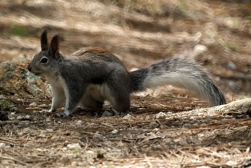 Mammal
 Abert's squirrel
Sciurus aberti
A tasseled-eared squirrel of ponderosa pine forests at Mesa Verde, Rocky Mountain, and Great Sand Dunes, nicknamed the scrabbit.
-
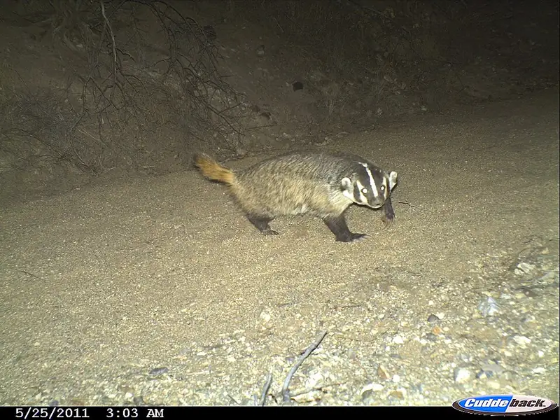 Mammal
 American badger
Taxidea taxus
A short, wide-bodied digger with a white-striped face, common on the grasslands of Yellowstone and Badlands, that can vanish underground in minutes.
-
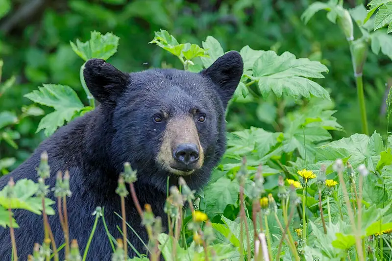 Mammal
 American black bear
Ursus americanus
The bear you're most likely to meet east of the Rockies, a strong tree-climber that eats mostly plants and comes in black, brown, or cinnamon.
-
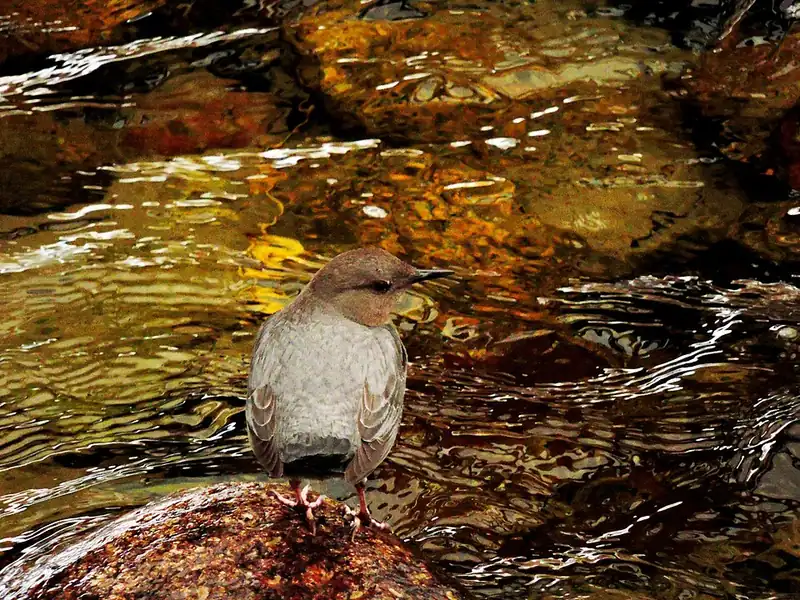 Bird
Bird American dipper
Cinclus mexicanus
A stream-gray songbird that walks along the bottom of cold mountain creeks to hunt, the only songbird in North America that does.
-
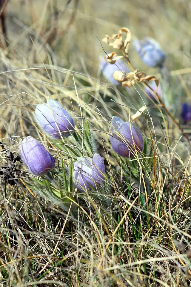 Plant
Plant American pasqueflower
Pulsatilla patens ssp. multifida
A furry, purple-blue prairie flower that beats the grass out of the ground each spring, blooming before almost anything else is green.
-
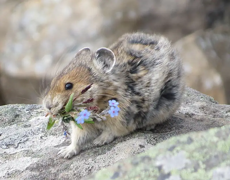 Mammal
 American pika
Ochotona princeps
A small round cousin of the rabbit that lives in mountain rock piles at Rocky Mountain, Mount Rainier, and North Cascades, and never sleeps through winter.
III
History
Who shaped this place
Indigenous nations
- Southern Ute Indian Tribe — The park calls the Nuuchiu (Ute) the oldest continuous residents of Colorado and of Rocky Mountain National Park, people who lived at higher elevations in summer and moved down to the plains in winter. The park notes that the spelling Nuuchiu is specific to the Southern Ute Indian Tribe, and that the three Ute tribes today represent 13 original bands.
- Ute Mountain Ute Tribe — The Ute Mountain Ute Tribe's reservation is the only one of the three Ute reservations the park lists that spans three states, Colorado, New Mexico and Utah. The park notes that the three modern Ute tribes represent 13 original bands and each has its own way of spelling the Ute name.
- Ute Indian Tribe of the Uintah and Ouray Reservation — The Ute Indian Tribe of the Uintah and Ouray Reservation is one of three Ute tribes the park counts as the oldest continuous residents of Colorado and of the park itself. The park gives its reservation as the Uintah and Ouray Reservation in Utah, and notes that the three tribes spell the Ute name differently.
- Northern Arapaho Tribe — Areas of the park made up part of the Hinono'ei (Arapaho) extended territory, and the park says those bands were seasonal residents of the Rockies by the time settlers arrived.
- Cheyenne and Arapaho Tribes — The Cheyenne and Arapaho Tribes are in Oklahoma, and Rocky Mountain lists them as a nation of its own, separate from the Northern Cheyenne Tribe of Montana and the Northern Arapaho Tribe of Wyoming.
- Northern Cheyenne Tribe — The park counts the Tsistsistas (Cheyenne) as seasonal residents of the Rocky Mountains by the time settlers arrived, and the Northern Cheyenne Tribe's reservation is now in Montana.
- Comanche Nation — Rocky Mountain lay within the extended territory of the Comanche Nation, whose people regularly came into these places. The Nation is in Oklahoma today, and the park counts the Comanche among the tribes it works with.
- Eastern Shoshone Tribe — The country in and around Rocky Mountain made up part of the Eastern Shoshone Tribe's extended territory, and the park says its people came into these places often. The tribe shares the Wind River Reservation in Wyoming with the Northern Arapaho.
- Kiowa Indian Tribe of Oklahoma — The park places the Rocky Mountain country inside the Kiowa's extended territory as well. The Kiowa Indian Tribe of Oklahoma is in Oklahoma today.
- Assiniboine and Sioux Tribes of Fort Peck — Rocky Mountain's country sat inside the extended territory the park attributes to the Lakota, Dakota, Nakota and Nakona peoples, who travelled to these places regularly. The Assiniboine and Sioux Tribes hold the Fort Peck Reservation in Montana today.
Advocates
- Enos Mills↗ — Naturalist and campaign leader, 1909-1915
Innkeeper of Longs Peak Inn and a former U.S. government lecturer on forestry under Gifford Pinchot. He launched the park campaign in 1909, wrote thousands of letters, and gave 42 lectures in his peak year. Newspapers called him the father of Rocky Mountain National Park, and he served as its unofficial first interpretive guide.
- J. Horace McFarland — American Civic Association president
President of the American Civic Association and a key Washington advocate who pressed the case for the park through the federal channels Mills could not reach from Colorado.
- Robert Sterling Yard — National Parks Association publicist
A publicist for the national-parks movement who helped carry the Rocky Mountain campaign into the national press alongside the founding of the National Park Service.
- Stephen Mather — Founding NPS director
The first director of the National Park Service, who with USGS engineer Frederick Newell backed the designation and the early development of the park.
Detractors
- U.S. Forest Service — 1909-1915
Under Gifford Pinchot's multiple-use doctrine, the Forest Service initially opposed transferring national forest reserve land to a single-use national park, a fight that helped cut Mills' original proposal down by more than half.
- Grazing and mining interests — Western (Grand County) side
Stock-grazing and mining interests on the western side of the Divide resisted the park, and local irrigation interests worried about water rights, concerns later addressed by carving out the Grand Lake water-diversion project.
Timeline
Enos Mills launches the campaign
Enos Mills, innkeeper of Longs Peak Inn and a former federal lecturer on forestry, began the formal campaign for a national park in the fall of 1909, writing thousands of letters and giving dozens of lectures. Newspapers later called him the father of Rocky Mountain National Park.
Arapaho place names recorded
University of Colorado student Oliver Toll, Arapaho elders Gun Griswold and Sherman Sage, and interpreter Tom Crispin rode a two-week pack trip through the range and documented Arapaho names for dozens of features, published as Arapaho Names and Trails. The names were recorded, not discovered.
Rocky Mountain National Park established
President Woodrow Wilson signed the Rocky Mountain National Park Act on January 26, 1915 (38 Stat. 798), creating the tenth national park from about 358 square miles of national forest land. The park was dedicated September 4, 1915 at Horseshoe Park. Boundary fights had cut Mills' original proposal by more than half.
Trail Ridge Road opens
Trail Ridge Road opened over the Continental Divide in 1932, with the high section finished in 1933. At 12,183 feet it is the highest continuously paved through-road in the country, and it follows a high traverse Indigenous peoples used for thousands of years.
UNESCO Biosphere Reserve
UNESCO designated the park a Biosphere Reserve in 1976, recognizing its montane-to-alpine ecosystem gradient.
Wilderness designation
Congress designated about 250,000 acres of the park as wilderness under the Omnibus Public Land Management Act (Public Law 111-11), giving the park's backcountry its strongest legal protection.
East Troublesome and Cameron Peak fires
The Cameron Peak Fire (208,913 acres, the largest in Colorado history) and the East Troublesome Fire (which burned about 22,000 acres inside the park) reshaped large portions of the west side and the Kawuneeche Valley. The pandemic also introduced the timed-entry permit system that fall.
About 4.1 million visitors
Visitation reached 4,108,816 in 2023. Roughly 70 percent of visits fall between June and September, and the timed-entry system has held annual totals near 4.1 million after a 2019 peak above 4.6 million.