Plan your visit
Rocky Mountain National Park Trip Planner
Tell us how long you have, who's along, and the season. We'll group it by region so you drive less and see more.
Day 1 Alpine Ridge (Trail Ridge Road) + West Side (Grand Lake / Kawuneeche Valley)
-

Alpine Visitor Center and alpine tundra
The highest visitor center in the National Park System, at 11,796 feet on Trail Ridge Road. From the parking area you can step onto tundra above treeline, where the growing season runs about 40 days and roughly 200 species of tiny alpine plants hug the ground. It is closed in winter. Give the altitude a day to settle before you come this high.
-

Trail Ridge Road and Forest Canyon Overlook
US 34 crosses the park for 48 miles between Estes Park and Grand Lake and reaches 12,183 feet, the highest continuously paved through-road in the United States. Eleven miles run above treeline, and pullouts at Forest Canyon and Gore Range look across valleys cut by Ice Age glaciers. Set aside at least a half day, and know it closes with snow.
-
Tundra Communities Trail at Rock Cut
A one-mile round trip from the Rock Cut parking area to the Roger Toll Memorial, most of it above 12,000 feet. The trail is paved at the start and then gravel, with about 200 feet of gain, crossing ground where pikas, marmots, and bighorn sheep live. Lightning is the real hazard above treeline; be off the ridge by noon in summer.
-

Holzwarth Historic Site
A 1917 homestead in the Kawuneeche Valley that became the Holzwarth Trout Lodge dude ranch. The log cabins sit a half-mile walk from the parking area on a level gravel trail; in summer rangers and volunteers open the buildings and tell the family's story. In winter the trail is not plowed, and the site is reached on snowshoes or skis.
-
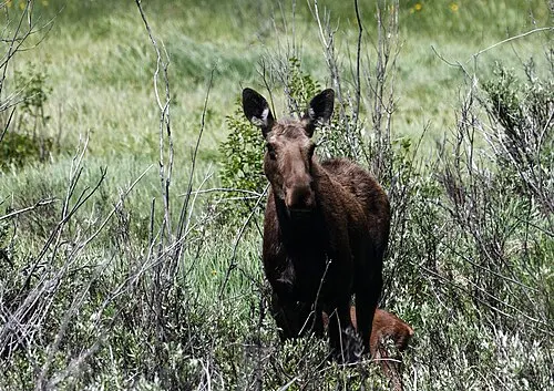
Kawuneeche Valley moose viewing
The west side is the park's moose country: look along US 34 where willows and aquatic plants grow. Moose return to the same feeding patches year after year and can be active at any hour, so scan slowly from the pullouts. Give them room; a moose can run 35 miles per hour, and cows with calves are protective.
Day 2 East Gateway (Estes Park / Beaver Meadows) + Bear Lake Road Corridor
≈55 min drive from Alpine Ridge (Trail Ridge Road)
-

Estes Park gateway
The town on US 36 at the Beaver Meadows entrance, and the last cluster of gas, groceries, and lodging before the park. The Beaver Meadows Visitor Center sits at 7,840 feet, open year round, with the park film, water, and flush toilets. On summer mornings the wait at the entrance station can run 30 minutes or longer.
-

Longs Peak viewpoint
Longs Peak is the park's only fourteener, and its flat summit and east face are visible from the east side without a climb. The trail to the top runs 8.0 miles one way and gains about 4,885 feet, with a class 3 scramble on exposed rock; it is not a family hike. Drive CO-7 south of Estes Park for the view and leave the summit to climbers.
-
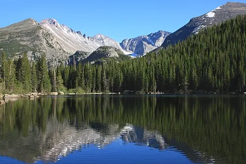
Bear Lake shore and nature loop
A half-mile loop around Bear Lake at 9,475 feet, at the end of Bear Lake Road. The first stretch is paved and wheelchair accessible, then becomes packed dirt around the shore. It is the shortest walk to a lake-and-peaks view in the park and the trailhead for the climb to Nymph and Dream lakes. Parking fills early in summer, so use the Park & Ride shuttle.
-

Nymph, Dream, and Emerald lakes
A 3.6-mile round trip from Bear Lake up through three lakes, climbing about 605 feet to Emerald Lake below Hallett Peak. Nymph Lake at a half mile is the short turnaround, and Dream Lake at 1.1 miles is the usual family goal. The trail is dirt and rock with roots, and the last stretch to Emerald can hold snow into June.
-

Sprague Lake loop
A flat 0.8-mile loop on packed gravel, dirt, and boardwalk around Sprague Lake, with benches, a fishing pier, and the Continental Divide across the water. The park measures the average running slope under 3 percent, which makes it the most stroller-friendly trail in the corridor. Moose are seen here at dawn and dusk.
-

Moraine Park elk rut at dusk
From mid-September into October, bull elk move into Moraine Park and bugle through the evening. Moraine Park is one of several meadows that close to off-road foot travel from 5 p.m. to 10 a.m. during the rut, so watch from the road and established trails. Keep at least 75 feet back; a bull can close that distance fast.
Day 3 South End (Lily Lake / Wild Basin)
≈30 min drive from East Gateway (Estes Park / Beaver Meadows)
-

Lily Lake loop
A flat 0.8-mile loop on boardwalk and gravel just off CO-7 south of Estes Park, with Longs Peak across the water. The park lists the Lily Lake Trail as open to power-driven mobility devices, one of only a few trails with that access. It sits outside the main entrance, so a timed-entry reservation is still required in summer.
-

Wild Basin to Ouzel Falls
A 5.4-mile round trip from the Wild Basin Ranger Station up the North St. Vrain drainage to Ouzel Falls, climbing about 950 feet past Copeland Falls and Calypso Cascades. The trail is dirt and rock, with a footbridge at the falls. This south end sees far fewer people than Bear Lake, and there is no water at the trailhead.
If you have more time
-
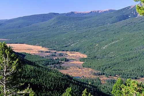
Green Mountain Trail to Big Meadows
A 3.6-mile round trip from the Green Mountain Trailhead on the west side, climbing about 606 feet through lodgepole and aspen to the meadow at the base of Green Mountain. The Kawuneeche Valley opens below, and this is a quieter, uncrowded side of the park. Dirt trail the whole way.
Plans by trip length
One day in Rocky Mountain National Park
In one day, Bear Lake Road Corridor: Bear Lake shore and nature loop, Nymph, Dream, and Emerald lakes.
Two days in Rocky Mountain National Park
Two days adds East Gateway (Estes Park / Beaver Meadows): Estes Park gateway, Longs Peak viewpoint; Alpine Ridge (Trail Ridge Road): Alpine Visitor Center and alpine tundra, Trail Ridge Road and Forest Canyon Overlook; West Side (Grand Lake / Kawuneeche Valley): Holzwarth Historic Site, Kawuneeche Valley moose viewing.
Three days in Rocky Mountain National Park
Three days adds South End (Lily Lake / Wild Basin): Lily Lake loop, Wild Basin to Ouzel Falls.
Best time to visit Rocky Mountain National Park
The best time to visit Rocky Mountain National Park is fall, when most of the park is open. In winter, Alpine Ridge (Trail Ridge Road) and Bear Lake Road Corridor and West Side (Grand Lake / Kawuneeche Valley) close with snow.
Trails on this plan
- Bear Lake shore and nature loop0.5 mi · 20 ft gain · easy · source
- Lily Lake loop0.8 mi · 10 ft gain · easy · source
- Sprague Lake loop0.8 mi · 0 ft gain · easy · source
- Tundra Communities Trail at Rock Cut1 mi · 200 ft gain · easy · source
- Green Mountain Trail to Big Meadows3.6 mi · 606 ft gain · moderate · source
- Nymph, Dream, and Emerald lakes3.6 mi · 605 ft gain · moderate · source
- Wild Basin to Ouzel Falls5.4 mi · 950 ft gain · moderate · source
Common questions
How many days do you need for Rocky Mountain National Park?
Rocky Mountain National Park fills about 3 days at an easy pace — West Side (Grand Lake / Kawuneeche Valley) & Alpine Ridge (Trail Ridge Road), Bear Lake Road Corridor & East Gateway (Estes Park / Beaver Meadows), South End (Lily Lake / Wild Basin).
Can you see Rocky Mountain National Park in one day?
Yes — pick one area: Bear Lake Road Corridor (Bear Lake shore and nature loop, Nymph, Dream, and Emerald lakes, Sprague Lake loop). You'd skip West Side (Grand Lake / Kawuneeche Valley) and Alpine Ridge (Trail Ridge Road) and East Gateway (Estes Park / Beaver Meadows) and South End (Lily Lake / Wild Basin), but it's a full day.
What's the best time to visit Rocky Mountain National Park?
Aim for fall; that's when its roads and trails are fullest.
Is Rocky Mountain National Park good with young kids?
Yes — the easier, shorter stops work well with little kids: Alpine Visitor Center and alpine tundra, Trail Ridge Road and Forest Canyon Overlook, Tundra Communities Trail at Rock Cut, Holzwarth Historic Site.
Is Rocky Mountain National Park doable with limited mobility?
Several stops are short and low-effort: Alpine Visitor Center and alpine tundra, Trail Ridge Road and Forest Canyon Overlook, Holzwarth Historic Site, Kawuneeche Valley moose viewing. Check current trail and road conditions with the park.