SD
Badlands National Park
Eroded buttes and mixed-grass prairie in western South Dakota, the country the Oglala Lakota call mako sica, the bad lands.
Established
We camped three nights at Cedar Pass, picked up junior ranger packets at Ben Reifel Visitor Center the first afternoon, and drove the loop road with the windows down before we did anything else. The thirty minutes Big and Little went out of sight off Fossil Exhibit Trail is its own story, written up in we lost them for thirty minutes off Fossil Exhibit Trail. The structured sections below are the homework we did before we drove in, now caught up with what we actually did: which overlooks earned the stop, which trails fit short legs, and the logistics that catch families off guard on the prairie.
Badlands is mostly a drive-and-stop park, and the paved Badlands Loop Road (SD-240) delivered on that: 31 miles between the Wall and Cactus Flat exits off I-90, with Big Badlands Overlook, Pinnacles, Yellow Mounds, and Prairie Wind all short looks from the car. We walked the Window and Fossil Exhibit boardwalks, and off Fossil Exhibit we did what the park’s Open Hike Policy allows and most parks do not: left the boardwalk for the formations behind it, which is where the thirty minutes happened. Notch Trail’s ladder was closed while we were there, its safety wire broken and awaiting repair; trail conditions change season to season, so check the NPS alerts page before you go rather than trust this page. Saddle Pass, a short trail almost entirely uphill with a hand-over-hand last third, earned its climb: the grass tableland on one side, the whole broken edge of the Wall dropping away on the other, the same ground at two different stages of the same process.
The land is the homeland of the Oglala Lakota, who call this country mako sica, which the NPS translates as bad lands. The English name, per the NPS, likely came through the French les mauvaises terres a traverser, “bad lands to travel across,” which the French likely derived from the Lakota. The South Unit lies within the Pine Ridge Indian Reservation, on land the Oglala Sioux Tribe granted under a 1976 easement and the Park Service holds in trust for the tribe; we stayed north of there the whole visit.
What Erika kept coming back to on the drive out was how temporary all of it is. The Badlands erode about one inch a year, fast for rock, and NPS estimates the whole formation will have eroded away within another 500,000 years. The rivers only started cutting this landscape about 500,000 years ago, which means what we were standing in front of is roughly halfway through its own life. The fossils keep turning up along the walls for the same reason the walls keep changing shape: the ground is still leaving.
The wildlife showed up on the drives more than on any trail: prairie dog towns strung the whole length of the loop, a bighorn ram that held still above the road near the Pinnacles, a wild turkey working the gravel shoulder. We heard a killdeer calling around Cedar Pass Campground every night and never once saw it. No bison; the park keeps its herd out on Sage Creek Rim Road and we never got that far west. Two things shape the whole trip regardless of season. The first is the sky: summer afternoons run into the 90s and 100s with no shade, and the thunderstorms that build over the prairie turn violent fast; NPS warns that the open buttes are lightning hazards, so hike early or late and watch the western horizon. The second is supplies: there’s no water past Ben Reifel Visitor Center and only the seasonal Cedar Pass Lodge restaurant inside the park, so sort water jugs and lunch in Wall or Interior first. We stopped in Wall both ways, which is its own kind of homework: the free ice water and root beer floats at Wall Drug, and a walkable main street where every parking spot still has a post for tying a horse.
I
Basic info
- Established
- 1978
- Area
- 242,756 acres
- Visitors (2022)
- 1,006,809
- Elevation
- 2,460–3,340 ft
- Designation
- National Monument (1939)
- Designation
- National Park (1978)
II
Logistics
Before you go
- Getting there
- From Rapid City, South Dakota, the park is 75 miles east, just south of I-90. Take Exit 131 to the Northeast Entrance or Exit 110 at Wall to the Pinnacles Entrance, then drive the Badlands Loop Road (Hwy 240). NPS
- How many days
- NPS's pass-through driving tour takes 3 to 6 hours: an overlook, the 1.5-mile Notch Trail, the visitor center, and the Badlands Loop Road. NPS has no plan for a longer stay. NPS
- Entrance fee
- Entry costs $30 per private vehicle for 7 days (2026). An America the Beautiful pass covers entry, and the park takes cards only. NPS
- Pets
- Only where cars go: campgrounds, picnic areas, paved and gravel roads, and parking lots, on a leash 6 feet or shorter (2026). Trails, visitor centers, the Badlands Wilderness, and prairie dog towns are off-limits. NPS
Seasons
Spring
- The park greens up and the back roads turn to gumbo. Sage Creek Rim Road can go impassable after rain.
- 40s to 70s °F. Wildflowers on the prairie; cooler mornings for the open trails.
- A good shoulder window if you watch the mud. The paved Loop Road stays open; the gravel roads are a gamble when wet.
Summer
- Hot and exposed, with violent afternoon thunderstorms. NPS calls this the lightning season, and the open buttes are the hazard.
- 90s to 100s °F. No shade on the trails and no water past the visitor center.
- Hike by 9 a.m. or after 5 p.m. Watch the western sky and get off the high ground before a storm builds. Carry your own water.
Fall
- The best season. The bison rut runs early September and the Sage Creek roundup is typically October.
- 60s to 70s °F. Long gold light late in the day on the wall.
- Cooler rock and thinner crowds make this the most comfortable hiking of the year. Time the open trails for the last hour of light, when the buttes go warm.
Winter
- Snow, wind, and sub-zero cold are all possible. Roads usually stay open but plowing is slow.
- Teens to 40s °F, colder in a cold snap. Bison drift to the lower draws.
- The quietest season under a dark winter sky. Cedar Pass Lodge and its campground are closed; Sage Creek Campground stays open and free.
Badlands National Park with kids
Badlands is a drive-and-stop park: the paved Badlands Loop Road (SD-240) carries about 99 percent of visits, and the headline overlooks are a few steps from the car. Off-trail hiking is legal here, which is unusual in the National Park System, so the loose mounds past a boardwalk are fair game with supervision, provided everyone has agreed on a turnaround landmark before they start climbing. The trade is heat, no shade, and no water on the trails, plus afternoon lightning that kills people in the open most summers. The plan is front-loaded: fill water at Ben Reifel Visitor Center and time the open trails for morning or evening.
- Badlands runs two free booklets at Ben Reifel Visitor Center, a Junior Ranger book and a separate Junior Paleontologist book; the paleontology track pairs with the Fossil Exhibit Trail.
- The easiest wins are the boardwalk trails off the Door and Notch lot: Window Trail (0.25 mi, accessible) and the Fossil Exhibit Trail (0.25 mi loop).
- Notch Trail (1.5 mi round-trip) climbs a roughly 50-rung log-and-cable ladder bolted to a cliff; it suits confident older kids but it is vertical and exposed, so turn back at the ladder if anyone is uneasy.
- Trail conditions and closures change here, and the Notch ladder is the first thing to close when its hardware needs repair; check the NPS current conditions and alerts page before you plan a day around any one trail.
- Past the Door boardwalk the mounds break line of sight within about a minute of climbing, and they look the same in every direction; pick a turnaround landmark everyone can name before anyone starts up.
- Saddle Pass Trail (0.25 mi round-trip, about 300 ft of elevation change per NPS) is the short, steep option: a scramble up loose clay onto the tableland, rated strenuous, with the White River valley behind you at the top.
- Prairie dog towns along the gravel Sage Creek Rim Road are a reliable kid favorite; watch from a distance because NPS warns the colonies can carry plague.
- There is no water past Ben Reifel Visitor Center and only one sit-down restaurant in the park, at Cedar Pass Lodge; carry water and pack food.
- Bison roam free in the Sage Creek area; NPS sets a 25-yard minimum, so stay in the vehicle near animals on the road.
Accessibility
Most of the headline views are roadside pullouts on the paved Loop Road, reachable from the car: Big Badlands Overlook, Pinnacles Overlook, Yellow Mounds Overlook, and Prairie Wind Overlook are all short, near-level looks from the rail. Two trails are boardwalk and close to accessible. The rest of the named trails are unimproved dirt, loose mound, and in one case a cliff ladder.
- Window Trail: a 0.25-mile accessible boardwalk to a natural opening in the wall, stroller-friendly.
- Fossil Exhibit Trail: a 0.25-mile boardwalk loop with replica skulls, level and stroller-friendly.
- Big Badlands, Pinnacles, Yellow Mounds, and Prairie Wind overlooks: short, near-level looks a few steps from the parking pullouts.
- Notch Trail (cliff ladder), Saddle Pass (a steep clay scramble with about 300 feet of elevation change), and the loose mounds past the Door boardwalk are not accessible; Sage Creek Rim Road is gravel and can be impassable when wet.
Things you can't miss
Natural places
Big Badlands Overlook↗
The first view for most arrivals, just inside the northeast entrance off I-90 Exit 131. The Badlands Wall drops away from the flat prairie tableland to the eroded basin below, and the whole panorama reads from the rail at a short paved pullout. It faces east into the sunrise, which makes it the morning bookend to a Pinnacles sunset if the family camps at Cedar Pass between the two. The land is Oglala Lakota homeland, the country they call mako sica.
Pinnacles Overlook↗
A sunset and sunrise vantage near the north entrance at I-90 Exit 110, looking west over a wall of spires and the Sage Creek basin. The base dossier notes the better light comes driving east in the evening, with the sun behind you, so eastbound from Pinnacles toward Ben Reifel is the photographer's order. Sunrise here is emptier still. Bighorn sheep are regular on the rock below the railing.
Yellow Mounds Overlook↗
One of the few stops on the Loop Road where the color is not white and tan. Banded yellow and red paleosols, ancient fossil soils, are exposed below the gray Sharps Formation near Dillon Pass. Per the NPS, the yellow is a fossil floodplain that weathered roughly 30 million years ago, before the gray ash-rich mudstones buried it. It is a roadside pullout with no walking required, which suits a stop between trails.
Sage Creek Rim Road and the Badlands Wilderness↗
A gravel road along the north edge of the 64,144-acre Badlands Wilderness, designated in 1976, where bison roam free. Per USGS, the species was nearly gone from the region by the early 1900s and was reintroduced to Badlands in 1963; this is the most reliable place in the park to see a herd. Stay in the vehicle near animals, where NPS sets a 25-yard minimum, and check the weather, because the gravel can go impassable when wet. The mixed-grass prairie here is the grassland that sustained the buffalo the Lakota depended on.
The prairie tableland↗
The half of the park most visitors drive past: the flat mixed-grass prairie on top of the wall, not just the eroded buttes below it. This is the largest protected mixed-grass prairie in the National Park System. Summer afternoon thunderstorms build fast over it and turn violent, and NPS warns that the open buttes are lightning hazards, so the prairie is best read from a pullout with the western sky in view. The buttes below are this same tableland after the rain and rivers cut into it.
Oligocene fossil beds↗
These mudstones hold one of the richest Oligocene mammal records anywhere, collected by paleontologists since the 1840s and the scientific case behind the park's first protection. Recent finds keep coming: a Santuccimeryx skull recovered here in 2016 was named for the longtime NPS paleontologist. The Big Pig Dig near Conata Picnic Area ran from 1997 to 2008 and yielded more than 19,000 fossils. Collecting is prohibited anywhere in the park; the place to see the bones up close is the Fossil Exhibit Trail.
Nearby attractions
Minuteman Missile National Historic Site↗
A separate NPS unit on the same I-90 corridor at Exit 131 (Cactus Flat), minutes from the park's northeast entrance. The Delta-09 silo and Delta-01 launch control facility preserve a Cold War Minuteman II site; entry is free, and ranger-led tours of the launch control center are reservation-only and book out. It pairs naturally with a Badlands day for an older kid drawn to 20th-century history, on prairie that sits within Oglala Lakota ancestral range.
Wall and the Wall Drug Store↗
The gateway town at I-90 Exit 110, about seven miles north of the Pinnacles Entrance per NPS. Ted and Dorothy Hustead bought the town drugstore in December 1931, and in the summer of 1936 Dorothy's idea was to put signs out on the highway offering free ice water to travelers crossing the hot prairie; per Wall Drug, cars were pulling in before Ted had finished planting them. The ice water is still free and the coffee is still five cents. The store has spread across most of a block since, a run of shops and a cafe and a backyard dinosaur, and its billboards will have been counting down at you for a couple of hours before you arrive. We drank root beer floats and worked slowly through the shopping, which runs from rock and fossil cases to boots to a great deal nobody needs. The rest of Wall is a short walk end to end. Little found the rails set into the main-street parking spots for hitching a horse.
Our pick for places to stay
Cedar Pass Campground↗
The developed campground near Cedar Pass and the Ben Reifel Visitor Center, reservable through the lodge concessioner. It has potable water and flush toilets in season, the in-park amenity edge over Sage Creek, and the sites face the wall, so sunrise lands on the buttes from the tent. We camped here in mid-September 2026. The sites sit close enough to Ben Reifel Visitor Center to walk over for a junior ranger booklet or for the evening program at the Cedar Pass Amphitheater, which is the same short walk back in the dark. Killdeer called around our site after sundown. The park runs a summer night-sky program at that amphitheater under skies dark enough that it is pursuing International Dark Sky Park certification. For free, primitive, year-round camping in the bison range instead, Sage Creek Campground sits at the end of the gravel rim road with pit toilets and no water.
Our pick for viewpoints and camping
Prairie Wind Overlook↗
A Loop Road pullout that looks out over the open mixed-grass prairie rather than the eroded wall, the quiet counterpoint to the busier spire overlooks. It is a good place to show kids the other half of the park, the grassland that is the largest protected mixed-grass prairie in the National Park System. No walking required; the view is the whole stop.
Trails worth the time
Fossil Exhibit Trail↗
A boardwalk loop with replica skulls and exhibits of the Oligocene mammals pulled from these mudstones: the entelodont Archaeotherium, sometimes called the terminator pig, alongside Hyaenodon, oreodonts, and the land tortoise Stylemys. Fully boardwalk and stroller-friendly, it is the kid-paleontology payoff of the park and the natural pairing with the Junior Paleontologist booklet. No fossil collecting anywhere in the park.
Door and Notch trails↗
The cluster off one Loop Road lot where you stand inside the eroded wall instead of looking at it. The Door Trail runs a boardwalk to a gap in the wall, then loose mounds marked by numbered posts; off-trail walking is legal in Badlands, so the mounds past the boardwalk are fair game with supervision. The terrain does one thing worth knowing first: the mounds break line of sight within about a minute of climbing, and they look the same in every direction, so agree on a turnaround landmark before anyone starts up. The Notch Trail climbs a roughly 50-rung log-and-cable ladder to a ledge above the White River valley, vertical and exposed, with rattlesnakes possible on the rock. Turn back at the ladder if anyone is nervous. Conditions and closures change here: the Notch ladder was shut for repair when we came through in September 2026 after a safety cable broke, so check current conditions with NPS before you build a day around it. No shade, no water.
Saddle Pass Trail↗
A quarter mile round trip, rated strenuous by NPS, with roughly 300 feet of elevation change over that distance per NPS. It is the shortest climb in the park and one of the steepest: the route goes straight up the face of the Badlands Wall on loose gullied clay and comes out on the prairie tableland with the White River valley open behind you. That trade, a few minutes of scrambling for the whole view, is what makes it worth doing with kids who want to work for something. At the top it meets the Castle and Medicine Root Loop trails if anyone wants to keep walking. The clay turns slick when wet, the same gumbo that closes the gravel roads, so skip it after rain. No shade, no water.
Our pick for things to do nearby
Prairie dog town watching↗
The black-tailed prairie dog towns along the gravel Sage Creek Rim Road are reliable, loud, and a near-guaranteed kid favorite. Watch from a distance and do not approach or feed them, because NPS warns the colonies can carry plague. Bison often graze the same flats, which turns one slow drive into a two-animal stop. The colonies are part of the grassland the buffalo depend on, in Oglala Lakota homeland.
Common questions
- When should we go with kids?
- September or October. Fall is the comfortable window: 60s to 70s °F, long gold light, and the bison rut in early September. Spring greens up but the back roads turn to gumbo when wet. Avoid mid-summer afternoons, when temperatures hit the 90s and 100s and violent thunderstorms make the open buttes a lightning hazard.
- How long do we need?
- The Badlands Loop Road (SD-240) runs 31 miles between I-90 Exit 110 (Wall) and Exit 131 (Cactus Flat). It takes about an hour and a half nonstop, more like three to four hours with overlooks and a short trail or two. A day covers the North Unit; the South Unit is a separate, services-free trip.
- Where do we get water, gas, and food?
- Fill water at Ben Reifel Visitor Center; there is none past it on the trails. Cedar Pass Lodge has the only sit-down restaurant inside the park, seasonal from about April to October. Otherwise the gateway towns are Wall (Exit 110, including the Wall Drug complex) and Interior, just south of the Loop Road.
- Is the off-trail hiking really allowed?
- Yes. Badlands permits off-trail hiking, which is unusual in the National Park System, so the loose mounds past a boardwalk like the Door Trail are fair game with supervision. You are responsible for your own navigation, and the same hazards apply: lightning on the buttes, rattlesnakes, heat with no shade or water, and no fossil collecting anywhere in the park.
- Where do we camp or sleep?
- Cedar Pass Campground near Ben Reifel Visitor Center is reservable through the lodge concessioner and has potable water and flush toilets in season. Sage Creek Campground, at the end of the gravel Sage Creek Rim Road, is free, first-come, open year-round, and primitive (pit toilets, no water), set right in the bison range. The only in-park lodging is the Cedar Pass Lodge cabins.
- Whose homeland is this?
- Badlands sits in the homeland of the Oglala Lakota, who call this country mako sica, which the NPS translates as bad lands and says the French name (and through it the English) likely derives from. The South Unit lies within the Pine Ridge Indian Reservation and is co-managed with the Oglala Sioux Tribe; the White River Visitor Center is staffed seasonally by the Oglala Sioux Parks and Recreation Authority. The NPS names 22 associated tribal nations.
- Why are the badlands called the badlands?
- Because the country is hard to cross. The Oglala Lakota call it mako sica, which the NPS translates as bad lands, and the French name for the same ground was les mauvaises terres a traverser, bad lands to travel across; the NPS says the English name likely came through the French, which derived it from the Lakota (per NPS).
- Do we need a reservation to visit Badlands National Park?
- No timed entry. You buy a 7-day entrance pass at one of the three entrance stations or on Recreation.gov, and the park takes cards only (2026).
Wild things at Badlands National Park
See all 39 →-
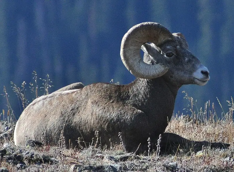 Mammal We saw it
 Bighorn sheep
Ovis canadensis
A wild sheep of cliffs and canyons, where rams carry heavy curled horns and both sexes cross steep rock other animals can't.
-
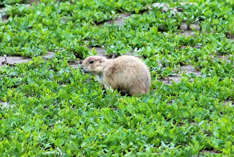 Mammal We saw it
 Black-tailed prairie dog
Cynomys ludovicianus
A burrowing ground squirrel, not a dog. Its towns along Theodore Roosevelt's scenic loop mow the grass short and pull bison and pronghorn in to graze.
-
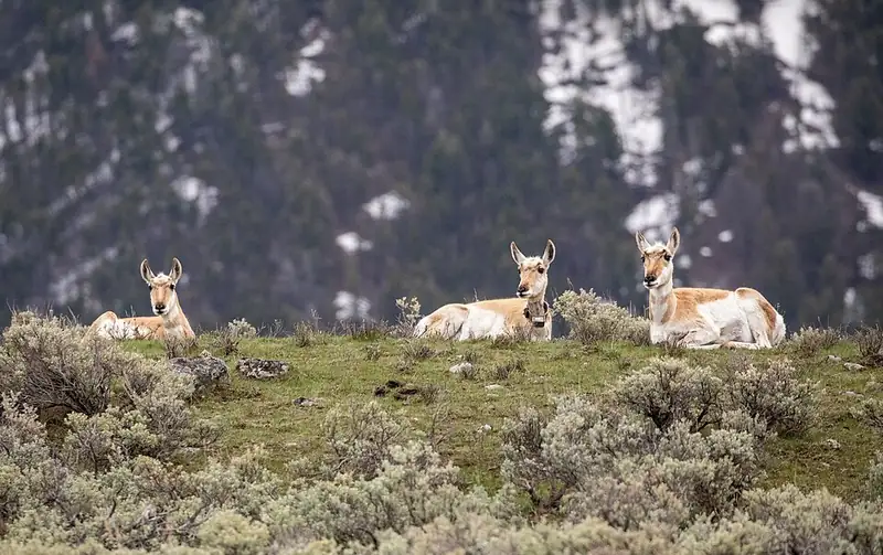 Mammal We saw it
 Pronghorn
Antilocapra americana
North America's fastest land mammal, seen in Yellowstone's northern range and at Lava Beds, built to outrun a predator that went extinct 12,000 years ago.
-
 Mammal We saw it
 White-tailed deer
Odocoileus virginianus
The most common large mammal in eastern parks, running through the woods and waving a white tail like a flag when it bolts.
-
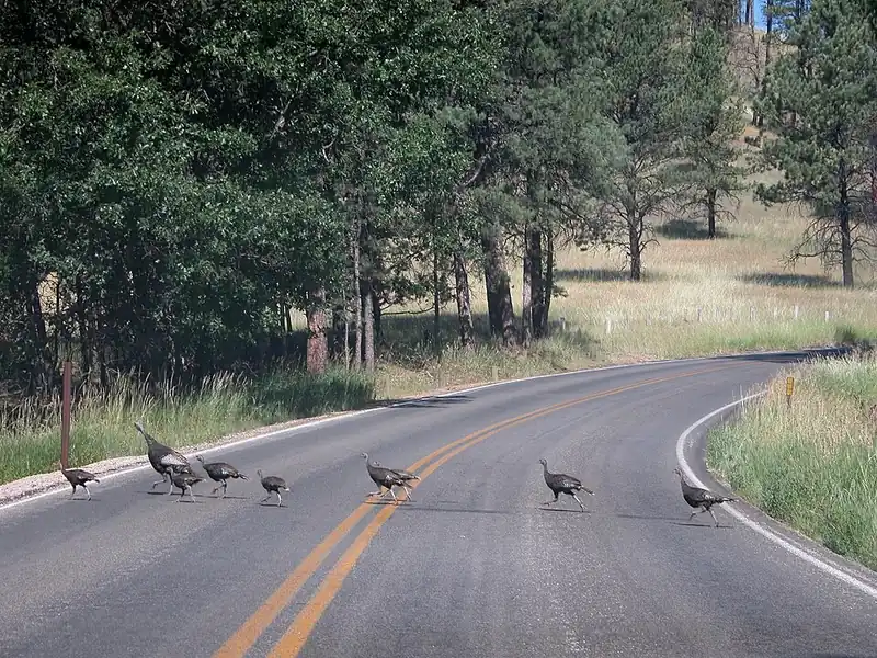 Bird We saw it
 Wild turkey
Meleagris gallopavo
A forest bird in a park with almost no forest. Badlands turkeys hold to the wooded draws, because a turkey needs a tree to sleep in.
-
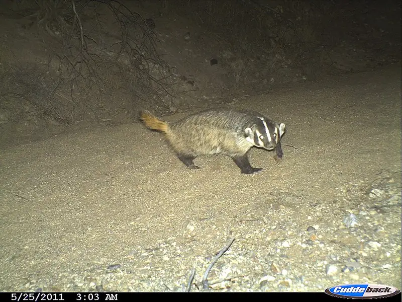 Mammal
 American badger
Taxidea taxus
A short, wide-bodied digger with a white-striped face, common on the grasslands of Yellowstone and Badlands, that can vanish underground in minutes.
III
History
Who shaped this place
Indigenous nations
- Oglala Sioux Tribe (Oglala Lakota) — Badlands' South Unit is entirely tribal trust land, held in trust for the Oglala Sioux Tribe, and a 1976 memorandum of agreement between the park and the tribe set out shared priorities from recruiting and fee revenue to bison management.
- Cheyenne River Sioux Tribe — The Cheyenne River Sioux Tribe's own history says its reservation's land base was set by the 1851 and 1868 Fort Laramie Treaties, and that the four Lakota bands living there knew no boundary to their territory before that, travelling the plains in search of bison.
- Rosebud Sioux Tribe (Sicangu Lakota) — The Ben Reifel Visitor Center at Badlands is named for Ben Reifel, a Sicangu Lakota born on the Rosebud Indian Reservation, who was the first Lakota elected to Congress and served from 1961 to 1971.
- Standing Rock Sioux Tribe — Standing Rock's own history records that the Great Sioux Reservation set up by the 1868 Fort Laramie Treaty covered all of present-day South Dakota west of the Missouri River, which is country the park sits in, and that article 11 kept off-reservation hunting rights over a far larger area to the south and east.
- Lower Brule Sioux Tribe — The Lower Brule Sioux Tribe says its homeland has no formal boundaries, and that the Sicangu centered their territory on the White River from its mouth to the margins of the Black Hills.
- Northern Cheyenne Tribe — The Northern Cheyenne Tribe's home today is the Northern Cheyenne Indian Reservation in southeastern Montana, where its tribal council draws members from five districts, Ashland, Birney, Busby, Muddy and Lame Deer.
- Northern Arapaho Tribe — The Northern Arapaho Tribe is based on the 2.2 million acre Wind River Reservation, between the Wind River Range and the Owl Creek Mountains.
Advocates
- Peter Norbeck↗ — U.S. Senator and former Governor of South Dakota
Pushed for the original 1929 authorization of Badlands as a national monument; the same senator campaigned for Mount Rushmore and lent his name to the Norbeck Wildlife Preserve.
- Ben Reifel↗ — Member of Congress, 1961 to 1971 (Sicangu Lakota / Rosebud Sioux Tribe)
The first Lakota elected to Congress, an enrolled citizen of the Rosebud Sioux Tribe (Sicangu, or Brule, Lakota). The park's main visitor center at Cedar Pass is named for him.
- James Abourezk and George McGovern↗ — U.S. Senators from South Dakota, 1970s
Congressional drivers of both the 1976 South Unit memorandum of agreement with the Oglala Sioux Tribe and the 1978 redesignation of the monument as a national park.
Detractors
- Oglala Lakota landholders on Pine Ridge↗ — 1942 to 1945
Families were displaced from the Pine Ridge Aerial Gunnery Range during World War II, when the military took roughly 341,725 acres for bombing practice with days of notice. Much of that land became the South Unit, and the loss remains a live grievance.
- Ranchers and grazing-permit holders — 1976 wilderness designation
Local ranchers and grazing-lease holders contested the 1976 Badlands Wilderness designation, which closed off range they had used.
Timeline
Badlands National Monument authorized
Congress authorized a national monument under the act of March 4, 1929 (45 Stat. 1553, codified at 16 U.S.C. 441), signed by President Calvin Coolidge. Senator Peter Norbeck and Representative William Williamson of South Dakota drove the authorization; paleontologists had been collecting Oligocene mammal fossils from these mudstones since the 1840s, and the scientific value carried the early protection argument.
FDR proclaims the monument
President Franklin D. Roosevelt proclaimed Badlands National Monument on January 25, 1939, ten years after the authorizing act. Much of the North Unit Loop Road grade and its pullouts were built by Civilian Conservation Corps crews in this period.
Pine Ridge Aerial Gunnery Range
During World War II the U.S. military took roughly 341,725 acres of the Pine Ridge Indian Reservation for a bombing and gunnery range; Oglala Lakota families were given days to evacuate. Most of that land later became the park's South Unit, and the displacement is current history, not closed.
Wilderness designation and the South Unit agreement
Congress designated the 64,144-acre Badlands Wilderness under the Wilderness Act, where bison reintroduced in 1963 roam free. The same year, a memorandum of agreement between the NPS and the Oglala Sioux Tribe set up joint management of the South Unit (the Stronghold and Palmer Creek districts), entirely on the Pine Ridge Indian Reservation.
Redesignated a national park
The National Parks and Recreation Act of 1978 (Public Law 95-625, signed November 10, 1978 by President Jimmy Carter) redesignated Badlands National Monument as Badlands National Park and folded the South Unit into the park boundary by statute. Senators James Abourezk and George McGovern were among the congressional drivers.
The Big Pig Dig opens
Visitors Steve Gasman and Jim Carney spotted fossil bone near the Conata Picnic Area, opening a quarry that ran 15 field seasons. The Big Pig Dig closed in 2008 after more than 19,000 fossils were removed, including entelodont and other Oligocene mammal remains.
Tribal national park proposal
The Oglala Sioux Tribe pursued establishing the South Unit as the first tribal national park, fully managed by the tribe; the NPS supported the concept in 2012. As of 2025 the enabling legislation has stalled in Congress and the question is unresolved.
New genus of fossil deer named
Researchers led by Badlands paleontologists Mattison Shreero and Ed Welsh described Santuccimeryx, a new genus of small hornless Oligocene deer, from a skull a Geoscientists-in-the-Parks intern reported in 2016. The genus is named for NPS senior paleontologist Vincent L. Santucci. The park runs a summer night-sky program at the Cedar Pass Amphitheater, and as of June 2026 it is in the application process for International Dark Sky Park certification, which is not yet awarded.