UT
Arches National Park
More than 2,000 sandstone arches in the desert five miles north of Moab, the country Edward Abbey wrote into Desert Solitaire.
Established
The visitor center sits just inside the entrance. On the 22nd we stopped there first, and a ranger handed over the Junior Ranger packet. The park film was already running in the theater, so we sat through it before we drove in. The film does the geology first and then sends you out to find the evidence, which is the right order for a packet full of blanks. The two days are in Two Oaths. The hour in the sand is the one I keep coming back to.
Arches is a high desert park on the Colorado Plateau with the densest concentration of natural stone arches in the world: more than 2,000 documented, from sliver-thin cracks to spans over 300 feet, per the NPS. The rock is Entrada Sandstone laid over older layers, and the whole stack sits on a salt bed that flowed upward and cracked the stone above it. The park gets 8 to 10 inches of rain a year. That is enough. Water works into the sandstone, dissolves the calcite holding the grains, and the openings follow the cracks.
Balanced Rock is 9.2 miles from the visitor center and 128 feet tall. The cap weighs 3,600 tons. The loop around it is 0.3 mile. Our name for the stem was “natural mortar,” which is close to right and not the mechanism. The cap is Entrada Sandstone on Dewey Bridge mudstone, which is softer, and the mudstone is the part leaving. Nothing is balanced. The smaller formation beside it, Chip-Off-the-Ol’-Block, collapsed in the winter of 1975 to 1976.
The Delicate Arch trail is 3 miles round trip and climbs 480 feet. We took the Upper Viewpoint instead: 0.5 mile with stairs, across the canyon from the arch. The opening beneath it is 46 feet high and 32 feet wide. At sunset the rim opposite fills with people. The NPS says hundreds come. The line of figures along the edge that evening was that long. The arch was an outline against the sky, and the far rim went dark behind it.
The NPS records ten nations with ancestral and traditional ties to the park, including the Hopi Tribe, the Navajo Nation, the Southern Ute Indian Tribe, the Ute Indian Tribe of the Uintah and Ouray Reservation, the Ute Mountain Ute Tribe, the White Mesa Ute, and the Zuni Tribe. The Ute petroglyph panel at Wolfe Ranch shows figures on horseback, which places the panel after 1600, when the Ute are thought to have acquired horses. The NPS says the panel is believed to have some Ute images. It was the clearest record we found of a nation’s hand.
The Windows is the loop for short legs. It runs about a mile, with a gentle climb to North and South Window, which stand side by side, and Turret Arch framed from the far side of the loop. The return can be the same trail or the primitive loop, which is uneven and has steps. There is no water at the trailhead.
We came back on the 24th for the two short walks at the north end. Sand Dune Arch is 0.4 mile round trip, and most of the trail is deep sand between two fins. The arch sits low. Skyline Arch runs the same 0.4 mile, with 28 feet of elevation change. In 1940 a boulder fell out of the opening and roughly doubled it. The pieces are still at the base, about 0.2 mile down the trail. We stopped at the visitor center on the way out, where Big and Little took the Arches oath and collected the badges.
Arches did not require a timed-entry reservation in 2026. The park announced the change on February 18, 2026. A valid entrance pass is still required at the entrance station. Water is available at the visitor center and at Devils Garden Campground. Most trailheads have none. There is no food service and no lodging in the park. Moab is about 5 miles south on US 191. We filled the water jugs and the fuel tank there.
From our visit
- Visitor center. The film ran, the packet came over the counter, and Big and Little worked the exhibits until we called them.
- Balanced Rock. We walked the 0.3-mile loop at the end of the afternoon. From the far side the cap and the stem line up, and the whole thing looks like it should already be down.
- Sand Dune Arch, then Skyline Arch. The sand at Sand Dune was deep enough to sit in, and it held Big and Little for an hour. At Skyline the opening was high in the wall, with the 1940 rockfall still at the base.
We drove into Moab with sand in the floor mats.
I
Basic info
- Established
- 1971
- Area
- 76,679 acres
- Visitors (2024)
- 1,463,000
- Elevation
- 4,085–5,653 ft
- Designation
- National Monument (1929)
- Designation
- National Park (1971)
II
Logistics
Before you go
- Getting there
- The entrance is 5 miles north of Moab, Utah, on US 191, or 22 miles south of I-70 at Crescent Junction. Canyonlands Field (CNY) is 11 miles from the entrance, and Salt Lake City International (SLC) is 230 miles. NPS
- How many days
- Half a day covers the whole park road, with 10-minute stops and a short walk at The Windows, Delicate Arch Viewpoint, or Balanced Rock. NPS plans nothing longer. A second half-day fits one of its longer hikes, such as the full Devils Garden trail to Dark Angel. NPS
- Entrance fee
- Entry costs $30 per private vehicle (2026), and NPS does not say how many days it lasts. An America the Beautiful pass covers entry. NPS
- Pets
- Only on roads, parking areas, campgrounds, and picnic areas, on a leash 6 feet or shorter (2026). Pets are barred from every trail, overlook, and building, even in a carrier. NPS
Seasons
Spring
- Peak season and the family window. The 2022 to 2025 timed-entry pilot ran in spring; for 2026 the park dropped the reservation requirement, but trailhead lots still fill early.
- 50s to 80s °F. Claret-cup cactus blooms along the slickrock.
- The best season for kids. Check the park page for the current entry rules and start at the Windows before the lots fill.
Summer
- Heat is the limiting factor. Monsoon storms arrive after the Fourth of July; flash floods can close roads in minutes.
- 90s to 100s °F. Slickrock surface temperatures can hit 150 °F. Heat-related rescues are routine.
- Hike before 9 a.m. or skip the exposed trails entirely. Save the afternoon for the visitor center and a Moab lunch.
Fall
- Second-best season. During the 2022 to 2025 pilot, timed entry ran into late October; 2026 has no reservation requirement.
- 50s to 80s °F. Cottonwoods yellow along the Colorado River.
- Cooler rock, thinner crowds than spring, and the river corridor turns gold.
Winter
- No timed entry. Devils Garden Campground stays open but Loop B closes.
- 20s to 50s °F. Occasional snow dusts the arches.
- The quietest season. Snow on red sandstone is the trade for cold mornings and short daylight.
Arches National Park with kids
Arches is a high-density arch park where the headline features sit close to the road, which suits short legs. The signature hike, Delicate Arch, is exposed slickrock the family plans to skip with small kids. The Windows section packs the most arches per step. There is no water past the visitor center and no food inside the park, so the planning is front-loaded: fill jugs and pack lunch in Moab first.
- Junior Ranger booklets are free at the visitor center and can be mailed if you forget to grab one.
- Strollers are useless past the Windows paved viewpoints; bring a kid carrier.
- The Windows Loop (1 mi, mostly flat, three arches) and Sand Dune Arch (0.4 mi sandy box canyon) are the easiest wins.
- Skip Delicate Arch with small kids: 3 miles, 480 ft of gain, no shade, drop-offs near the arch. Use the Delicate Arch Viewpoint instead.
- No water past the visitor center and no food in the park. Pack lunch and fill water in Moab, 5 miles south, before driving in.
Accessibility
Several headline stops are at or near the car. The Lower Delicate Arch Viewpoint is wheelchair-accessible a few steps from the lot. Balanced Rock and Park Avenue overlooks are short, near-level looks from the pullouts. Most named trails beyond the Windows viewpoints are unimproved sand and rock.
- Lower Delicate Arch Viewpoint: wheelchair-accessible, a few steps from the parking lot; the no-climb way to see the arch across the canyon.
- Balanced Rock pullout: the 128-foot formation is at car-door distance; the 0.3-mile base loop is optional and mostly level.
- Park Avenue overlook: the top viewpoint is a few steps from the car; the canyon trail below is unimproved.
- Windows Loop and Sand Dune Arch are short but unpaved (packed sand, rock steps, deep soft sand). Delicate Arch Trail is exposed slickrock, not accessible.
Things you can't miss
Natural places
Delicate Arch↗
The freestanding arch on the Utah license plate: a 46 ft × 32 ft opening per NPS, roughly 52 ft tall, standing alone on a bowl of slickrock with the La Sal Mountains behind it. Reaching the base is a 3-mile round-trip with about 480 ft of gain over open rock, no shade, and a narrow ledge with exposure near the arch. The base dossier flags it as one to skip with small kids. First light is colder and quieter than the sunset crowd; park at the Wolfe Ranch lot rather than the Upper Viewpoint.
Landscape Arch↗
The longest natural arch in North America, 306 ft per NPS, thinned to a ribbon at its middle. A 60-foot slab fell from it in 1991, after which the Park Service closed the trail that ran under the span; the rock is eroding in real time, and the people standing beneath it in old photographs no longer can. The graded gravel approach, 1.8 miles round-trip per NPS, is the flattest, most kid-doable leg of the Devils Garden trail.
Balanced Rock↗
A 128-foot formation: a caprock of harder Entrada Sandstone perched on an eroding pedestal of softer Dewey Bridge mudstone that wears out from under it. It shows in slow motion how every arch in the park eventually ends. The smaller companion formation, Chip-Off-the-Old-Block, fell in the winter of 1975 to 1976. A 0.3-mile loop circles the base on level ground, one of the shortest payoff walks in Arches. Edward Abbey's 1956 to 1957 ranger trailer stood near here while he wrote the notebooks that became Desert Solitaire.
Double Arch↗
Two arches that share one end of their span, formed by water cutting down from a single pothole instead of sideways through a fin, a different mechanism than most of the park's openings. The opening scene of Indiana Jones and the Last Crusade (1989) was filmed beneath it. The NPS-signed Double Arch trail is 0.6 miles round-trip on packed sand from the Windows lot, with rock to scramble up into the lower span. The Windows section is the highest arch-per-step density in the park, which makes it the place to go with short legs.
Fiery Furnace↗
A maze of narrow sandstone fins that holds shade and stays cool inside; the name describes how the rock glows at sunset, not the temperature. Going in requires a self-guided permit or a ranger-led hike, both booked ahead, and it is easy to get lost in. This is not a walk-up. For a family that hasn't pre-booked, the honest version is to look at it from Panorama Point, where the fins line up at dusk, and leave the labyrinth for a return trip.
Skyline Arch↗
A 0.4-mile round-trip walk to an opening high in a sandstone wall. In 1940 a large boulder fell out of the arch and roughly doubled the size of the opening; the remnants of that rockfall sit about 0.2 miles down the trail. The walk is easy, 28 feet of elevation change, and the arch is one of the closest big openings to the road.
Nearby attractions
Wolfe Ranch and the Ute petroglyph panel↗
A one-room log cabin the rancher John Wesley Wolfe built in 1906, a few hundred feet up the Delicate Arch trail from the Wolfe Ranch lot. A signed spur leads to a Ute petroglyph panel: riders on horseback and bighorn sheep carved into desert-varnished rock, dated after 1600 because the horses arrived with the Spanish. NPS names ten nations associated with this land, and this panel is the one place the park documents a single nation's work on the ground. A flat 15-minute add-on for families not climbing all the way to Delicate Arch.
Park Avenue↗
A corridor of tall sandstone walls and standing fins that Edward Abbey nicknamed for a city street. The viewpoint at the top is a few steps from the car, a good first look about a mile past the visitor center and the first major stop inside the entrance. The trail down through the canyon runs a mile one-way and needs a car shuttle to the Courthouse Towers end, so most families walk in a little and turn around.
Moab↗
The full-service town for the park, five miles south on US 191: the nearest gas, water, groceries, and hospital. There is no gas inside Arches and no water past the visitor center, so the jugs and the tank get filled here on the way in. Moab also stages Canyonlands' Island in the Sky district, about 40 minutes off, and Dead Horse Point State Park, which means a family can base in one motel strip and reach three parks.
Our pick for places to stay
Devils Garden Campground↗
The only campground inside Arches, 18 miles in among the fins at the end of the main park road, where the early and late light works the sandstone without the midday trailhead crowds. It has 51 sites per recreation.gov (including two group sites and one accessible site). Reservable March through October, full nearly every night, and first-come November through February, with Loop B closed in winter. No water on site in the off-season; fill at the visitor center. There is no lodge or hotel anywhere inside the park; everything else is in Moab.
Viewpoints and camping
Delicate Arch Viewpoint↗
How a family still sees Delicate Arch without the 3-mile slickrock climb. The Lower Viewpoint is wheelchair-accessible and a few steps from the lot; the Upper Viewpoint is a steeper half-mile round-trip up to a rock ledge with a closer line of sight. The arch sits across a canyon from both, a distant view but a real one, and the fair trade for skipping the exposed climb with small kids.
Balanced Rock at dusk↗
The pullout at the Windows Road junction puts the 128-foot formation at car-door distance, with the La Sal Mountains behind it to the southeast. Low evening light is when the caprock and the peaks line up, and no hike is required; the 0.3-mile base loop is optional. A good last stop before dark with tired kids already buckled in the car.
Trails worth the time
Windows Loop↗
A loop, mostly flat over packed sand and a few rock steps, past three large openings: North Window and South Window side by side in one fin (the "Spectacles"), with Turret Arch framing them from across the loop. NPS gives the Windows Loop as about a mile round-trip; the primitive trail around the back adds distance and drops most of the crowd. The base dossier names it the top kid trail in the park, the highest arch-density-per-step in Arches. No shade; carry water.
Sand Dune Arch↗
A 0.4-mile round-trip into a sandy slot between two tall fins that block the wind and most of the sun, so it stays cooler than the open trails. The base dossier flags it as the trail where kids love to dig; the floor is deep soft sand in a shaded box canyon. It connects to Broken Arch for a longer loop across open grassland and slickrock for families who want to keep going.
Common questions
- When should we go with kids?
- March or October. Spring (50s to 80s °F) is the prime family window; fall is the cooler second-best, with cottonwoods yellowing along the Colorado. Avoid July and August: slickrock surface temperatures can hit 150 °F and monsoon flash floods close roads.
- Do we need a timed-entry reservation?
- Not in 2026: the park announced on February 18, 2026 that it would not require timed-entry reservations this season. During the 2022 to 2025 pilot it was required for daytime entry in spring and fall, booked on recreation.gov at $2 per vehicle, with before-7-a.m. and after-4-p.m. entry exempt. The policy can change from year to year, so check the park page before you lock dates.
- Where do we get water, gas, and food?
- All of it in Moab, 5 miles south on US 191. There is no water past the visitor center, no gas in the park, and no in-park dining or concessioner. Fill the jugs and the tank and pack lunch before driving in.
- Is there cell service in the park?
- Spotty to nonexistent beyond the entrance. Download maps and any reservations before you drive in.
- What is the entrance fee?
- $30 per vehicle (2026), and no timed-entry reservation is needed this season. The $80 America the Beautiful annual pass pays off by the third national park unit in a year.
- Where do we camp or sleep?
- Devils Garden Campground is the only campground inside the park, 18 miles in, reservable March through October and first-come November through February. There is no in-park lodge or hotel; everything else is in Moab.
- Why is it called Arches National Park?
- The park is named for its natural stone arches. As late as 1970, park literature counted nearly 90, and surveys that began in 1973 have documented more than 2,000.
Wild things at Arches National Park
See all 14 →-
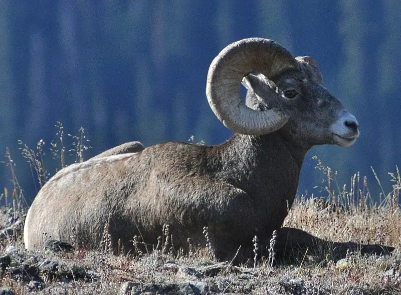 Mammal
Bighorn sheep
Ovis canadensis
A wild sheep of cliffs and canyons, where rams carry heavy curled horns and both sexes cross steep rock other animals can't.
-
 Mammal
Black-tailed jackrabbit
Lepus californicus
A big-eared hare of Joshua Tree, Lava Beds, Arches, and Canyonlands that dumps body heat through those ears and outruns coyotes in zigzags at 40 miles an hour.
-
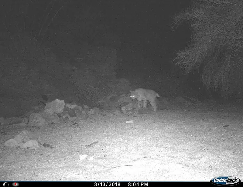 Mammal
Bobcat
Lynx rufus
A small wildcat about twice the size of a house cat, common but rarely seen, that can bring down prey many times its own weight.
-
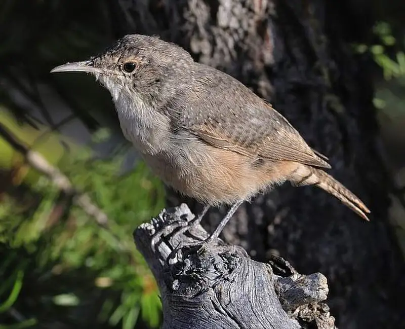 Bird
Canyon wren
Catherpes mexicanus
A small, rusty-brown songbird of canyon cliffs at Black Canyon, Arches, and Canyonlands, far more often heard than seen.
-
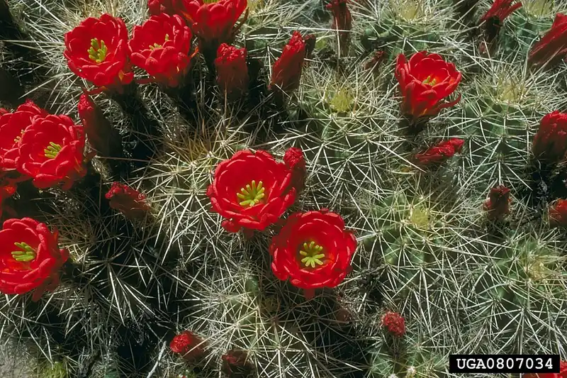 Plant
Claret cup cactus
Echinocereus triglochidiatus
A low, mounding desert cactus that bursts into bright red, cup-shaped flowers each spring on rocky ground across the Southwest.
-
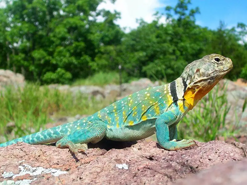 Reptile
Common collared lizard
Crotaphytus collaris
A bright, big-headed lizard with two black neck bands that can sprint on its back legs like a tiny dinosaur across desert rock.
III
History
Who shaped this place
Indigenous nations
- Hopi Tribe — Arches sits on the northern edge of Ancestral Pueblo country, and NPS names the Hopi Mesas among the places where the descendants of those builders live today. The park's own history page says few dwellings have been found inside Arches, so the people who farmed the Four Corners probably came through in season.
- Las Vegas Tribe of Paiute Indians — The Las Vegas Tribe of Paiute Indians of the Las Vegas Indian Colony is one of the ancestral homelands the park names for Arches.
- Moapa Band of Paiute Indians — The Moapa Band of Paiutes holds the first Southern Paiute reservation, established in 1872 in Nevada. NPS counts the Southern Paiute along the southwestern edge of the Colorado Plateau.
- Southern Ute Indian Tribe — Southern Ute representatives were among the five tribes the park invited into its ethnographic study of Arches, run with the University of Arizona's Bureau of Applied Research in Anthropology. The tribes told the researchers what the park's plants, animals, rock features, and landscape meant, and NPS says the results will inform management decisions and go into the park's articles, exhibits and programs.
- Zuni Tribe — Representatives of the Pueblo of Zuni took part in the ethnographic study the park ran with the University of Arizona, and NPS names the tribe A:shiwi.
Advocates
- Bates Wilson↗ — Superintendent of Arches Monument, 1949-1972
The "Father of Canyonlands" who ran Arches from headquarters while pushing it toward park status and lobbying for the much larger park across the Colorado River. His jeep tours with Interior Secretary Stewart Udall, starting in 1961, produced two parks: Canyonlands in 1964 and the elevation of Arches in 1971.
- Edward Abbey↗ — Seasonal ranger, 1956 and 1957
Worked April through September two seasons out of a Park Service trailer near Balanced Rock, where he kept the notebooks that became Desert Solitaire (1968), a polemic against "industrial tourism" that arrived three years before the park designation it helped popularize.
- Alexander Ringhoffer — Prospector and first non-Indigenous booster
Promoted the arches to the Denver & Rio Grande Western Railroad in 1923, calling the area "Devils Garden" and urging tourism. He publicized the arches; he did not discover them.
- Frank E. Moss & Laurence Burton↗ — Utah congressional sponsors, 1971
Senator Frank E. Moss (D-UT) and Representative Laurence Burton (R-UT) championed the legislation (S. 30) that elevated the monument to a national park under Public Law 92-155.
Detractors
- Uranium and potash interests — 1950s-1960s
Local Moab extractive interests opposed monument expansion, viewing federal protection as a constraint on industry during the Atomic Energy Commission's mid-century uranium boom in San Juan and Grand counties.
- Utah ranchers — 1969 expansion
The 1969 LBJ expansion proclamation drew criticism from ranchers losing grazing leases inside the enlarged monument boundary.
Timeline
Ringhoffer promotes the arches to the railroad
Prospector Alexander Ringhoffer wrote to the Denver & Rio Grande Western Railroad about the area he called "Devils Garden," urging tourism development. Passenger traffic manager Frank A. Wadleigh visited that September and recommended the area to NPS Director Stephen T. Mather. Ringhoffer promoted the arches; he did not discover them. The Ute and earlier peoples used this country for millennia.
Arches National Monument proclaimed
President Herbert Hoover signed Presidential Proclamation 1875 on April 12, 1929, creating Arches National Monument as two disconnected sections, the Windows and Devils Garden units, totaling about 4,520 acres.
FDR expands the monument
President Franklin D. Roosevelt enlarged the monument by proclamation, the first of two mid-century expansions.
LBJ doubles the monument
In one of his final acts in office, President Lyndon Johnson roughly doubled the monument's size by proclamation, a move that drew criticism from Utah ranchers losing grazing leases.
Elevated to national park
President Richard Nixon signed Public Law 92-155 on November 12, 1971, elevating the monument to Arches National Park at about 76,500 acres. The enabling bill was S. 30, championed by Senator Frank E. Moss and Representative Laurence Burton of Utah.
1,806,865 visitors, all-time peak
Visitation grew 73 percent between 2011 and 2021, peaking before the timed-entry pilot. The crowding at Devils Garden and the Delicate Arch lots drove the access-management plan.
Timed-entry pilot begins
Arches launched a seasonal daytime timed-entry reservation system to flatten the crowding curve. The pilot ran through 2025; on February 18, 2026 the park announced it would not require timed-entry reservations for the 2026 season.
About 1.46 million visitors
Visitation has flattened near 1.46 million under the timed-entry pilot, down from the 2021 peak. March and October remain the comfortable shoulder months for a family.