Pit River Tribe
A nation today
Background
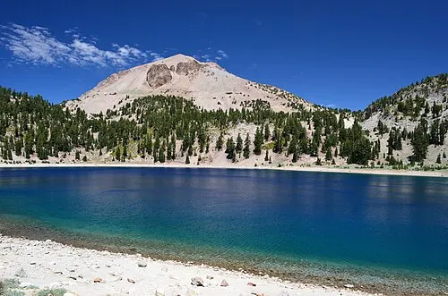
The Tribe's homelands are the area the Indian Claims Commission described in its findings of fact and opinion of July 29, 1959 in Docket No. 347. The rancherias inside it are XL Ranch, Montgomery Creek, Roaring Creek, Big Bend, Burney, Lookout and Likely. Two peaks corner the territory. Mount Shasta at 14,162 feet and Lassen Peak at 10,466 feet are its northwest and southwest corners, the Warner Range marks the eastern boundary with the Northern Paiute with peaks running from 7,843 to 9,934 feet, and twenty peaks over 6,000 feet break the interior into many separate valley and stream systems. Lassen Volcanic National Park lists the eleven bands of the Tribe by name, Ajumawi, Atsugewi, Atwamsini, Ilmawi, Astarawi, Hammawi, Hewisedawi, Itsatawi, Aporige, Kosalektawi and Madesi, and records that the federal government recognizes them together as the Pit River Nation. One band, the Hewisedawi, takes its name from Hewise, meaning "Up Above" or "On Top" in their language, and its villages ringed Goose Lake from Fandango Valley south through the Warner Mountains to Cedar Pass. The Tribe's water department runs two community public water systems, at the XL Reservation and at Montgomery Creek Rancheria, plus a transient system at the Chimney Rock Truck Stop.
Visit and learn
Tribal lands have their own laws. Check the nation's site before you visit.
Parks on its homelands
Lassen Volcanic National ParkEleven bands make up the Pit River Tribe, including the Atsugewi, who have lived since time immemorial in what Lassen Volcanic National Park calls the 100-mile square, spread across Shasta, Siskiyou, Modoc and Lassen counties. The Atsugewi wintered along Hat Creek and moved into the park's north and northwest in the warmer months. Source
Programs
Heritage Department
In 2011 the National Park Service formally designated the Pit River Tribe Heritage Program as a Tribal Historic Preservation Office, a designation the Tribe's own history states was made to strengthen its ability to manage and regulate cultural preservation on Pit River tribal lands. The program works across Modoc, Shasta, Lassen and Siskiyou counties, keeps oral histories, takes part in site field investigations and tribal consultation, and runs public information and community seminars on the Tribe's culture.
Environmental Programs Office
The office states its mission as protecting the lands, air and water for the benefit of current and future generations, and lists its program areas as inter-agency coordination and cross-jurisdictional watershed planning, tribal capacity development, geospatial information management, ecological restoration and research, surface water quality monitoring with benthic macroinvertebrate sampling, tribal youth science education, water resources planning, a native plant greenhouse, community gardens and alternative energy planning. It lists four EPA-approved quality assurance project plans, dated 2012 to 2015, covering surface water, benthic sampling, groundwater and cyanobacteria.
Water Department
The department supplies drinking water and water for fire prevention at the XL Reservation and Montgomery Creek Rancheria, and runs a third transient system at the Chimney Rock Truck Stop for travelers. It works with Indian Health Services, Rural Community Assistance Corporation and the EPA Pacific Southwest Region 9 Drinking Water Office, and the Tribe's page notes a growing need for certified water operators as current ones near retirement.
Sources
- https://www.govinfo.gov/content/pkg/FR-2026-01-30/html/2026-01899.htm
- https://pitrivertribe.gov/tribal-history/
- https://pitrivertribe.gov/pit-river-tribe-water-department/
- https://www.nps.gov/lavo/learn/tribes.htm
Checked September 2026.